
Unmissables
15 must-see mountain sites
Made famous by the Tour de France or simply for the breathtaking views they offer, immerse yourself in the great history of the French mountains.
Savoie / Hautes-Alpes
The Col du Galibier
The Col du Galibier (2645 metres), on the border between the Hautes-Alpes and Savoie departments, owes its fame primarily to the Tour de France. The world’s greatest cycling race has climbed this pass 59 times, including an unprecedented finish at its summit in 2011, the highest in the event’s history.
Before becoming a legendary summit of the Grande Boucle (from 1911), and even before the construction of the first motorable road (in 1879), the Col du Galibier was first and foremost a crossing point between the Dauphiné (France) and the kingdom of Piedmont-Sardinia for all those – smugglers, outlaws or delinquents – fleeing French justice.
Haute-Savoie
The Glières plateau
A limestone plateau in the centre of the Bornes massif, the Glières, with an average altitude of 1,450 metres, was first and foremost a Mecca for the Resistance. A management school was set up at Manigod, at the foot of the plateau, to train the maquisards.
In 1944, the Glières site was chosen for the parachute drops of weapons from England, from 14 February to 10 March. Two days later, the maquis was destroyed by the Germans, with considerable losses: 150 dead out of 465 maquis members. But this heroic sacrifice made a major contribution to the legend of the Resistance.
Isère
The shrine of Notre-Dame-de-la-Salette
Perched at an altitude of 1770 metres above Corps, this shrine is one of the most important places of pilgrimage in Europe.
On 19 September 1846, twelve years before the Lourdes apparitions, a “beautiful lady” appeared to two young shepherds, Maximin Giraud and Mélanie Mathieu-Calvat, aged 14 and 12. She warned them of afflictions and famine if they neglected prayer and piety, before disappearing in a halo of light.
Two days later, Melanie returned and found that the spring, which had constantly dried up in summer, was now giving water. From then on, pilgrims flocked there and the sick were treated near the spring. A basilica was built between 1852 and 1865, and a community of priests was founded to look after the pilgrims.
Hautes-Pyrénées
The Gavarnie cirque
A wall 1,700 metres high and 14 kilometres in circumference. This is the imposing Cirque de Gavarnie, a UNESCO World Heritage Site since 1997.
It became part of legend when Victor Hugo, in his famous poem “Dieu”, described it as “an impossible and extraordinary object”, a “colossus of nature”.
It is home to Europe’s largest waterfall (413 metres high) and the famous Brèche de Roland, an impressive natural gap 100 metres high and 40 metres wide in the cliffs above the Cirque de Gavarnie.
Isère
Mont Aiguille
A jutting out of the eastern cliffs of the Vercors, surrounded by sheer cliffs 350 metres high, Mont-Aiguille (2086 metres altitude) is considered one of the Seven Wonders of the Dauphiné.
Under the Ancien Régime, it enjoyed greater popularity than the giants of the Alps.
In November 1490, King Charles VIII of France even ordered Antoine de Ville, Lord of Dompjulien and a specialist in climbing strongholds, to climb to its summit. This he did in June 1492, along with seven other people, using ladders, ropes and grappling hooks. This event is considered to be the birth of mountaineering.
Puy-de-Dôme
The Puy-de-Dôme
This volcano in the Puys chain in the Massif Central gives its name to the département. Dormant for 12,000 years, the Puy-de-Dôme was awarded the Grands Sites de France label in 2008.
On 22 July 1876, Emile Alluard inaugurated France’s first permanent mountain meteorology laboratory at its summit.
It was also made famous by the installation of a TDF (television relay) mast in 1956, not to mention the fact that its slopes played host to the Tour de France cyclists on several occasions between 1952 and 1988, including a memorable duel between Anquetil and Poulidor in 1964.
From June 2012, the only way to get there will be by cogwheel train, following the route of the current road.
Haute-Savoie
The Aiguille du Midi
The most visible summit from the town of Chamonix – more so than Mont Blanc – the Aiguille du Midi (3842 metres above sea level) was first climbed in 1818, but its highest point was not reached until 1856.
However, it was the inauguration in 1955 of the cable car that runs from Chamonix directly up the north face of the Aiguille du Midi that made it a legend. Four years of work were needed to complete this cable car, whose arrival station is the third highest in the world.
Every year, 540,000 people – skiers (coming down from the famous Vallée Blanche), mountaineers and simple pedestrians – flock to its summit to admire one of the finest panoramas in the Alps.
Savoie
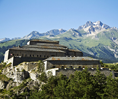
The Esseillon forts
There are five of these forts – Marie-Thèrèse, Marie-Christine, Victor-Emmanuel, Charles-Albert and Charles-Félix – built on a glacial lock slightly upstream of Modane in the Maurienne valley.
They were built between 1818 and 1833, according to the principles of Marc-René de Montalembert, namely that the forts should protect each other.
It was Austrian Chancellor Metternich, in 1815, who instigated their construction: their purpose was to block access to the Mont-Cenis pass, by preventing the passage of French armies. They were rendered useless in 1860 when Savoie became part of France and were abandoned in 1945, before extensive restoration work was undertaken in 1970.
Vosges
The Ballon d’Alsace
This summit at the southern end of the Vosges massif (1,247 metres above sea level), classified as a Grand Site National, offers an imposing panorama of the Black Forest to the east, the Bernese Alps to the south as far as Mont Blanc, which can be seen on a clear day, and the ridges of the Vosges to the north.
Renowned for the quality of its air, it is home to a wealth of wildlife (chamois, peregrine falcon, speckled nutcracker, raven, lynx, etc.) amid a varied flora (yellow gentian and bilberry). It is criss-crossed by numerous hiking trails (including the GR 5, GR 7 and GR 59).
It is also a popular spot for mountain bikers, paragliders and skiers (alpine and cross-country) in winter.
Haute-Savoie / Switzerland
Lake Geneva
This is the largest of the Alpine lakes, covering 582 km² and straddling Switzerland and France. Fed and drained by the Rhône, at an altitude of 372 metres, it has a maximum depth of 310 metres, and its waters are renewed every eleven years on average.
Like Lake Annecy and Lake Bourget, it was formed by the retreat of the Rhône glacier after the last ice age, nearly 15,000 years ago.
Another, more poetic explanation claims that the lake was created by an angel crying after God asked him to leave the northern Alps. Although navigation is sometimes difficult due to violent storms – which create waves of up to 2.50 metres – Lake Geneva is home to some 150 professional fishermen, attracted by perch, féra, trout and arctic char.
Haute-Savoie
Mont Blanc
The highest point in the Alps (measured at 4810.50 metres), Mont Blanc has not always had the same power of attraction as it does today. Until the 18th century, it was even called “the cursed mountain”, because of the “ice demons” who, according to legend, invaded the mountain pastures. It was not until 8 and 9 August 1786 that Jacques Balmat and Dr Michel Paccard made the first ascent of the roof of Europe.
Successive ascents – and the accidents that resulted from some of them – led to the creation of the Compagnie des Guides de Chamonix in 1823 and the PGHM (Peloton de Gendarmerie de Haute Montagne) in October 1958.
It is estimated that between 25,000 and 30,000 people attempt to climb Mont Blanc every year, with between 2,000 and 3,000 succeeding in reaching the summit.
Hautes-Alpes
The citadel town of Mont-Dauphin
This is undoubtedly the most ambitious urban development imagined by Vauban, the famous French military strategist, who is also responsible for transforming Briançon into one of the finest fortified towns in the Alps.
Noting the weakness of the Alpine border at the time of the Duke of Savoy’s attempts to penetrate it, Louis XIV asked Vauban to study ways of strengthening it. As early as 1692, Vauban had proposed fortifying this acropolis at the confluence of the Guil and Durance rivers, located below Guillestre.
In 1700, he asked for the enclosure to be extended and even for an advanced lunette to be created on the other side of the Guil gorge. This town, known as “Mont-Dauphin”, was never populated, and despite the construction of barracks, powder magazines, pavilions and churches, the project remained unfinished.
Hautes-Pyrénées
The Tourmalet pass
The highest road pass in the Pyrenees (2115 metres above sea level), the Col du Tourmalet has always been used by shepherds, pilgrims and pedlars, before the inauguration of a “thermal road” in 1864, financed by Napoleon III.
Like the Col du Galibier in the Alps, this “mauvais détour” (the meaning of the word “Tourmalet”) has been made famous by the Tour de France cycle race. It is even the most climbed pass by the Grande Boucle peloton, with 77 passes.
Situated at the foot of the Pic du Midi de Bigorre (2877 metres), in winter it is the junction between the ski resorts of La Mongie and Barèges, and has given its name to the “Grand Tourmalet”, the largest ski area in the French Pyrenees.
Alpes-Maritimes
The Valley of Wonders
Dominated by Mont Bégo (2873 metres above sea level), this valley in the Mercantour National Park is world-famous for its collection of rock engravings. It is the largest of its kind in Western Europe, with no fewer than 40,000 prehistoric engravings and 100,000 historical engravings.
Dating back to the end of the Neolithic period (between 3200 and 1500 BC), the engravings depict fairly simple geometric shapes (grids) and drawings of animals or tribal chiefs. The main engravings were moulded on site and can be seen at the Musée des Merveilles in Tende.
Hautes-Alpes
La Meije
This peak in the Ecrins massif (3982 metres above sea level), which overlooks the village of La Grave, is one of the most famous in the world of mountaineering. The conquest of its “Grand Pic” was the subject of a fierce competition, won in 1877 by an unlikely team made up of an elderly guide (Pierre Gaspard) and the young Baron Emmanuel Boileau de Castelnau.
It is also very popular with skiers: it gave its name to the “Vallons de la Meije”, the most prestigious off-piste ski area in France. For the anecdote, you should know that it was almost decapitated – literally – in 1933, because a certain Doctor Prompt was planning to build a hotel for pulmonary tuberculosis patients and an astronomical observatory there. But the summit was too narrow to accommodate the cable car station that would have brought patients and scientists to the summit!